Outcrop is a fundamental concept in mining geology and mineral exploration. It refers to the visible exposure of bedrock or mineral-bearing rock layers on the earth’s surface. In simple terms, an outcrop occurs when a rock formation that normally lies beneath soil or sediments becomes exposed and visible at the ground surface.
Outcrops provide valuable geological information because they allow geologists to directly observe rock structures, mineral compositions, and geological features without drilling or excavation. In mining exploration, studying outcrops is often the first step in identifying potential mineral deposits.
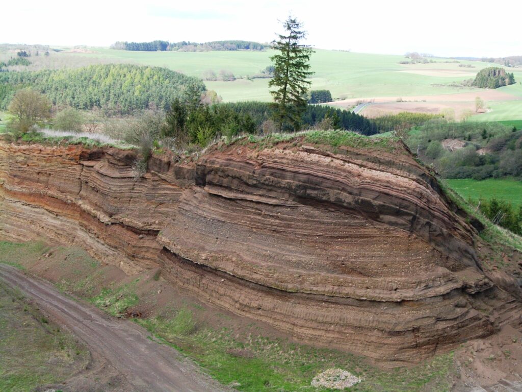
Rock layers are usually covered by soil, vegetation, and loose sediments. However, natural processes such as erosion, weathering, tectonic movements, and river action can remove these surface materials and expose the underlying rocks. These exposed rock surfaces are called outcrops.
Understanding outcrops helps mining engineers and geologists determine the structure, orientation, and composition of underground formations. This information is critical when planning exploration drilling, geological mapping, and mine development.

What is Outcrop in Mining?
In mining geology, an outcrop is defined as the portion of a rock formation that appears at the earth’s surface after the removal of soil or other covering materials. These rock exposures provide direct access to geological formations that would otherwise remain hidden underground.
Outcrops are important because they allow geologists to study rock layers in their natural environment. By observing the characteristics of the exposed rocks, geologists can determine the type of rock, mineral content, geological structure, and formation history.
Outcrops are commonly found in mountainous areas, river valleys, coastal cliffs, road cuts, and mining regions where erosion has removed surface sediments.
For mining professionals, outcrops are extremely valuable because they often provide the first visible evidence of mineralization. Many important mineral deposits, including gold, copper, iron, and coal, have been discovered by studying surface outcrops.
Formation of Outcrops
Outcrops form through various natural geological processes that remove the soil or sediment covering rock layers. These processes expose the underlying bedrock and make it visible at the surface.
Weathering
Weathering is the process by which rocks are gradually broken down by environmental factors such as temperature changes, water, wind, and chemical reactions.
Over long periods of time, weathering can remove loose surface materials and expose solid rock layers beneath them. This process contributes significantly to the formation of outcrops.
Erosion
Erosion occurs when natural forces such as flowing water, glaciers, wind, or ocean waves remove soil and sediment from the surface. Rivers often cut through layers of soil and rock, exposing bedrock along riverbanks and valleys.
In mountainous regions, erosion frequently creates large rock exposures that serve as excellent outcrops for geological study.
Tectonic Activity
Tectonic forces within the earth’s crust can uplift rock layers and push them toward the surface. Folding, faulting, and other structural movements can expose previously buried rock formations.
In many mining regions, tectonic uplift has played an important role in bringing mineral-bearing rocks closer to the surface, allowing them to form visible outcrops.
Human Activities
In addition to natural processes, human activities such as road construction, quarrying, and mining excavation can create artificial outcrops. These exposures are often used by geologists to study rock structures.
Types of Outcrops
Outcrops can appear in different forms depending on geological conditions and the processes that exposed the rock layers.
Natural Outcrop
Natural outcrops occur when rock formations become exposed through natural processes such as erosion, weathering, or tectonic uplift. These are commonly seen on mountain slopes, cliffs, and river valleys.
Artificial Outcrop
Artificial outcrops are created by human activities such as road cuts, quarry operations, construction projects, or mining excavations. These exposures often provide excellent opportunities for geological observation.
Continuous Outcrop
A continuous outcrop occurs when a rock layer is exposed over a long distance without interruption. Continuous outcrops are particularly useful for geological mapping because they clearly show the structure and orientation of rock layers.
Isolated Outcrop
An isolated outcrop refers to a small or scattered exposure of rock surrounded by soil or vegetation. These outcrops may provide limited geological information but can still indicate the presence of certain rock formations.
| Type of Outcrop | Description |
|---|---|
| Natural Outcrop | Formed through natural geological processes |
| Artificial Outcrop | Created by human excavation or construction |
| Continuous Outcrop | Long exposure of rock layer without interruption |
| Isolated Outcrop | Small scattered rock exposure |
Identification of Outcrops in the Field
Geologists use several techniques to identify and study outcrops during field investigations. Proper identification is essential for accurate geological mapping and mineral exploration.
Rock Color and Texture
The color and texture of exposed rocks provide important clues about their composition and formation. Different rock types have distinctive colors and grain structures.
Mineral Presence
Outcrops may contain visible mineral crystals or metallic minerals that indicate the presence of valuable deposits.
Fossil Evidence
In sedimentary rock formations, fossils found in outcrops can help geologists determine the geological age and environmental conditions during rock formation.
Structural Features
Features such as fractures, folds, and bedding planes can be observed directly in outcrops. These structures help geologists understand the geological history of the area.
Tools Used by Geologists
| Tool | Purpose |
|---|---|
| Geological Hammer | Break rock samples for examination |
| Brunton Compass | Measure strike and dip |
| Field Notebook | Record geological observations |
| GPS Device | Record location of outcrop |
Importance of Outcrop in Mining Exploration
Outcrops play a crucial role in mineral exploration and geological investigations. They provide valuable information about the distribution and structure of rock formations.
Mineral Deposit Discovery
Many mineral deposits have been discovered by studying surface outcrops. Visible mineralization in rock exposures often indicates the presence of valuable ore bodies underground.
Geological Mapping
Outcrops allow geologists to map rock formations and identify structural features such as faults, folds, and bedding planes.
Exploration Drilling Planning
Information gathered from outcrops helps determine the most effective locations for drilling exploration boreholes.
Cost Reduction
Surface geological studies reduce the need for extensive drilling, making mineral exploration more cost-effective.
Outcrop in Coal Mining
In coal mining regions, coal seams sometimes appear at the surface as outcrops. These exposures often provide the first indication of coal deposits.
Early coal miners frequently discovered coal seams by observing black rock layers exposed along hillsides or riverbanks.
Coal Seam Identification
Coal outcrops help geologists determine the thickness and orientation of coal seams.
Mine Planning
Outcrop information helps engineers design mine entries and determine the direction of underground galleries.
Outcrop in Surface Mining
In open-pit mining operations, outcrops provide essential geological information before excavation begins.
Engineers study surface outcrops to determine the distribution of ore bodies and the boundaries of mineral deposits.
Pit Design
Outcrop data helps engineers design safe pit slopes and bench configurations.
Resource Estimation
By analyzing outcrops, geologists can estimate the extent of mineralization and calculate potential resource quantities.
Challenges in Studying Outcrops
Although outcrops provide valuable geological information, geologists often face several challenges when studying them.
| Challenge | Description |
|---|---|
| Vegetation Cover | Plants and trees may hide rock exposures |
| Soil Cover | Thick soil layers may conceal bedrock |
| Weathering | Surface weathering may alter rock appearance |
| Limited Exposure | Only small sections of rock may be visible |
Modern Technology for Outcrop Mapping
Modern geological technologies have greatly improved the ability to study and map outcrops.
Satellite Imagery
Satellite images help geologists identify rock exposures across large regions.
Drone Surveys
Drones provide high-resolution aerial photographs of geological outcrops.
GIS Mapping
Geographic Information Systems allow geologists to store and analyze geological data digitally.
3D Geological Modeling
Advanced software enables geologists to create three-dimensional models of rock formations using outcrop data.
Frequently Asked Questions
What is an outcrop in mining?
Why are outcrops important in mineral exploration?
Where are outcrops commonly found?
Which tools are used to study outcrops?
Conclusion
Outcrop is an essential concept in mining geology because it provides direct access to rock formations exposed at the earth’s surface. By studying outcrops, geologists can understand the structure, composition, and orientation of rock layers.
Outcrops play a crucial role in mineral exploration, geological mapping, and mine planning. They often provide the first clues about the presence of valuable mineral deposits.
With the help of modern technologies such as satellite imagery, drone surveys, and digital geological modeling, the study of outcrops has become more accurate and efficient.
Understanding outcrops enables mining professionals to make informed decisions, reduce exploration risks, and improve the success of mining operations.